Attractions


Kallista VIC 3791
Eastern Sherbrooke Forest Walk
https://visitdandenongranges.com.au/activity/eastern-sherbrooke-forest-walk
Walk Length: 6.6 Kilometres (return)
Time: 2.5 hours
Grade: Easy/ Moderate (some steep sections)
Track: Mostly on management vehicle tracks
Start: Grants Picnic Ground
Finish: Grants Picnic Ground
Nearby: Kallista, Sassafras
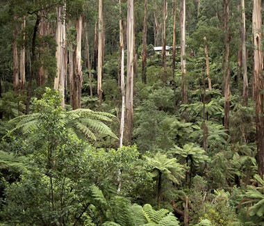
One of the top ten walks in the Dandenong Ranges this walk enables you to witness changing vegetation passing through cleared areas of bush created by successive wildfires of the early 1900s and vegetable growing during World War II, towering Mountain Ash and Messmate Stringybark trees, a wide variety of ferns and other wet and damp forest vegetation. This area boasts the highest density of superb lyrebird living together with wombats, samp wallaby, echidna, possums and powerful owls.


425 Burwood Highway, Wantirna South
Westfield Knox
https://www.westfield.com.au/knox
Westfield Knox is a super-regional shopping centre, outdoor entertainment and professional services complex located in the outer eastern Melbourne suburb of Wantirna South, in the Australian state of Victoria.


26 Observatory Road, Mount Dandenong Victoria 3767
Mount Dandenong, Victoria
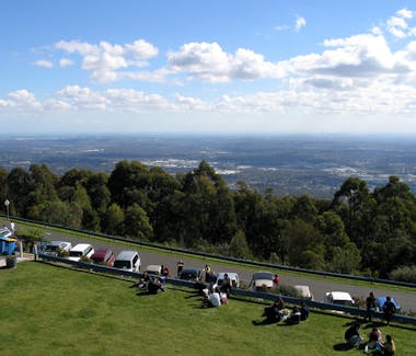
Mount Dandenong is both a mountain and a small township/suburb of Greater Melbourne, Victoria, Australia, 35 km (22 mi) east from Melbourne's central business district. Its local government area is the Shire of Yarra Ranges. At the 2006 Census, Mount Dandenong had a population of 1,276.
Light to moderate snowfalls occur on Mount Dandenong a few times most years, mostly frequently between late winter and late spring. The area around Mount Dandenong experienced a highly unusual summer snow fall on Christmas Day 2006.[2]


26 Observatory Road, Mount Dandenong Victoria 3767
Sky High Observatory - Mount Dandenong, Victoria
Mount Dandenong is both a mountain and a small township/suburb of Greater Melbourne, Victoria, Australia, 35 km (22 mi) east from Melbourne's central business district. Its local government area is the Shire of Yarra Ranges. At the 2006 Census, Mount Dandenong had a population of 1,276.
Light to moderate snowfalls occur on Mount Dandenong a few times most years, mostly frequently between late winter and late spring. The area around Mount Dandenong experienced a highly unusual summer snow fall on Christmas Day 2006.[2]


Vermont South VIC 3133, Australia
Bellbird Dell
Bellbird Dell is one of the12 bushland parks within the City of Whitehorse, Victoria Australia. It is also one of the parks within Whitehorse that includes a Community Parkland Advisory Committee. The purpose of the committee according to Whitehorse City Council is 'to provide opportunities for residents to become actively involved in the planning, promotion and care of parkland which is such a special feature in our Municipality.'
This website not only displays how beautiful Bellbird Dell is, but gives information about what the Committee is doing for the park and how you can too.
We hope you enjoy your visit to our website and come back again soon.
Happy walking,


291 George Street, Wantirna Victoria 3152


Healesville Victoria
Yarra Valley Wineries
The Yarra Valley is the name given to the region surrounding the Yarra River in Victoria, Australia. The river originates approximately 90 kilometres east of the Melbourne central business district and flows towards it and out into Port Phillip Bay. The name Yarra Valley is used in reference to the upper regions surrounding the Yarra River and generally does not encompass the lower regions including the city and suburban areas, where the topography flattens out, or the upper reaches which are in inaccessible bushland. Included in the Yarra Valley is the sub-region of Upper Yarra which encompasses the towns of the former Shire of Upper Yarra in the catchment area upstream of and including Woori Yallock. The Yarra Valley is a popular day-trip and tourist area, featuring a range of natural features and agricultural produce, as well as the Lilydale to Warburton Rail Trail.


Ferntree Gully Rd, Wheelers Hill VIC 3150, Australia
Oaks and Ashes Picnic Areas - Jells Park
Jells Park is nestled in the Dandenong Creek Valley, Wheelers Hill, away from the hustle and bustle of urban life. The park attracts over 900,000 visitors a year, with over nine kilometres of paths and trails, 127 hectares of wide open spaces and enough picnic areas for everyone to enjoy.
Trails and paths
The main Dandenong Creek Trail runs north-south through Jells Park, linking the Eastlink Track, Scotchmans Creek pathway and the Knox bike track (near Nortons Park). All paths are multi-use so you can take your choice of cycling, jogging, or simply strolling.
The conservation trail meanders around the eastern side of Jells Lake. As you pass through the wetlands and billabongs on this trail take a look at the variety of native bird life such as the Purple Swamphen, the White-faced Heron and everyone's favourite, the Pelican.
BBQs, picnics and playgrounds
Jells Park has many barbecue and picnic areas. Relax under the shade of the Pines, enjoy the lake views at the Elms, or watch the children enjoying the playground at Stringybark or Yabbie Hill. Please remember to take home all your rubbish for sorting and recycling.
